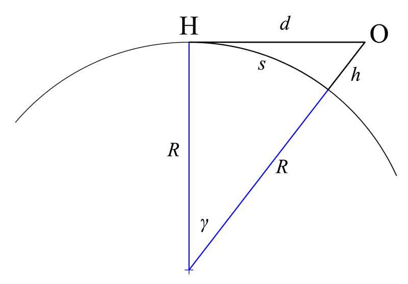
You can actually work out roughly how far away the horizon should be surprisingly easily. Just use the fact that if R is the radius of the Earth and you are at height h, then from you to the horizon to the center of the Earth back to you is a right angled triangle with one side of length R and the hypotenuse of length R+h. Therefore the distance to the horizon is sqrt(2Rh+h^2) which is roughly sqrt(2Rh).
The Earth is roughly 6370 km which is not far from 6400, so if your eyes are 2m = 0.002 km up then the horizon is about sqrt(264000.002) = sqrt(25.8) km away, which is roughly 5 km or a bit over 3 miles.
If you apply this to a 6 km tall mountain, the horizon is about sqrt(263706) km away which is about 276.5 km. So something of the same height at the opposite end of the horizon would be 553 km away. So the top distance of 538 km is pretty close to the maximum that we would expect.
What about an airplane? An airplane flies about 11 km up. So it can see around 375 km. If you work it out, that puts the horizon about 3.37 degrees below horizontal. This isn't much, but if you take a plumb line and a right angle on an commercial flight, it is enough to actually see that the horizon is below horizontal.
I had this question worded differently asked to me when I interviewed to do an undergrad at Cambridge. If you have a rope that is wrapped around earth and you lift it off the ground as much as possible, and you see that it is 10km above the ground, then how long is the rope?
I was not able to answer that question right away, and their hint to draw it helped a lot. I did not end up getting accepted.
In this case the "arbitrary filter" was filtering applicants to a university for very basic math knowledge, so I think assuming that it's correlated with success at that university is not very far fetched.
I don't think after playing 20 or so levels I was much smarter for it. It turned out to be a bunch of rules that were extremely limited. You do begin to appreciate trig much more.
If you are being given a geometry subject test and are prepared for it, this is fair game. If the question is just given out of the blue as a brain teaser, then no, the university is not mining useful signals at all.
When I did my university entrance interview (for maths, at Cambridge) the interviewers were clear that they expected that some subset of candidates would have seen the problem before, and some wouldn't -- for those in the first set they'd get them to quickly go through the problem and move onto the later parts which would be new to them; for those in the second set they'd provide sufficient guidance to let the candidate walk through the problem. The point was to get any particular candidate to a point in the problem sequence where this was something new to them, and then see how they tackled things. The idea that some applicants (usually from public schools) would have been very highly prepped for interview and others (usually from state schools) would not was clearly something they were well aware of and setting their interview design up to handle.
But how do you know it's a new problem? You can always fake a little struggle and thinking your way to the solution for a problem that you know the answer already.
I don't see anything tricky about that problem. It requires some junior high geometry and high school trig, and yes, I suppose you need to know the radius of the earth offhand. Still. That strikes me a lot more as a math fizzbuzz than as a brain teaser. A college applicant can be reasonably expected to know this stuff.
I suppose you need to know the radius of the earth offhand.
Or you can easily derive the radius if you remember that a meter was initially defined as 1/10,000,000 of the distance from the equator to the North Pole. So you can easily calculate the Earth's circumference, and from there the radius: 10,000,000 * 4 / 1000 / 3.1416 / 2 = 6366 km.
It also seems to be a less coherent version of the chicken from Minsk puzzle.
Perhaps it's multiple choice.
  A.  Dreadfully sorry, but I'm afraid I haven't memorized the circumference of Earth.
  B.  What do you mean?  Over the poles or 'round the equator?
  C.  Is that 10 km above at all points on the rope, or just one?
  D.  What's the rope made of?  Jute?  Sisal?  Nylon?  How far apart are the supports?  Young's modulus...
  E.  I don't know about that, but I have inherited a rather large quantity of string in 3-inch lengths...
There is a lot more than the Pythagorean theorem in that question. It would require remember a lot of middle school theorems from a long time ago; frankly calculus would be better.
The version I got, in a tech company interview, was how much longer would you need to make the rope to allow a cat to go under it. They were basically just look for 2 x Pi x Cat in this case.
That question is ambiguous. If you only need a single cat to go under the rope at some point, you just add a small arch for the cat to walk through. This requires a length of rope somewhat less than twice the height of the cat.
2 x Pi x Cat would levitate the rope by the height of the cat along the entire circumference of the Earth, allowing a billion cats to go under it simultaneously.
You could even make do with no additional rope if you're allowed to take advantage of terrain.
The answer to the first interpretation is considerably less than twice the height of the cat, and I think it's an interesting result as well:
Assuming a 0.3 meter high cat, you only need ~0.12mm of extra rope (about the width of two sheets of paper) to be able to pull it up at a point and let the cat through.
Follow-up question - after extending the rope by 0.12mm and pulling it up to allow the cat to pass under it, how far away are each of the two points where the rope lifts off the ground?
Haven't done any calculations but I would guess half of the Earth circumference? because if you want to minimize the length of the rope then you have to maximize distance between those two points.
If kovek's question was like the first image there, it'd be a simple radius/circumference calculation (2 * pi * 5km). But it sounds like the second image to me - which makes it into more of a horizon line problem.
Yeah, I know that. I'm just trying to add to the history of rope/earth/cat interview questions here. This was ~15 years ago by the way and to be clear we're talking about cats being able to pass anywhere, not the line of sight problem, which I agree makes it a little more interesting..,
I'm not sure if I understood you, but 2pi(height of the cat) would allow to make two additional round loops, each sufficient for a very cylindrical cat to go through.
The "multiply by 2pi" version of this problem is the one where you have to lift the rope by a cat's height all around the entire earth. So if you have an army of southern-hemisphere cats and they need to get to the northern hemisphere, but you have cunningly put a rope around the equator because you don't want dogs to invade, how much extra rope do you need to lift it to just let in the cats but not the dogs?
(I'm assuming all cats are shorter than all dogs.)
To be clear, they gave you the radius of the earth here, if you didn't already know it by heart? Otherwise, I'm not getting how you could solve this problem (assuming they didn't give you the angle that the arch formed, for example).
You don't need to know the radius of the earth unless you're asked for a numeric answer. The rope is 2 * pi * 10km longer than the Earth's circumference, since its radius is 10km more.
I think this is the wrong interpretation; your answer would be correct if the rope were hovering at a height of 10 km along the full length.
My interpretation is that the rope is pulled taut to a height of 10 km at a single point, so that it runs in a straight line to the horizon in either direction and lays on the ground the rest of the way; this is also relevant to the question of longest line of sight from a given height.
Yes, but I only posted that so you'd see which problem the GP is referring to: the second one. Unless somehow the rope is some special kind of non-flexible rope that always assumes the shape of a circle.
fwiw, this method doesn't seem to predict the list very well
as its not a list of just the highest peaks in the world
longest sightlines also depend on the surrounding topography that blocks or doesn't block a sightline
this seems to account for the numerous Spanish entries on the list, where the large Spanish plain with high peaks on either side, enables you to see from 1 peak to the other, w/o anything on the plain blocking your view
It didn't claim to predict the list very well. Its purpose is to give intuition about how far around the Earth we can see.
Also it shows that simply being tall (airplanes go higher than Everest) doesn't get you on the list. The second paragraph puts an upper bound on sight lines between two mountains of a given size. The longest sight lines are pretty close to that limit. And it gives a simple experiment that anyone can carry out from an airplane which will let you see the curvature of the Earth.
This is too simplistic of an approach. Suppose there is another 6km tall mountain just beyond the horizon, it will have a farther line of site to the peak of it than to the horizon just in front of it. This list seems to be a much more rigorous attempt.
It is meant to show how to calculate the position of the horizon on a smooth planet. Obviously your line of sight typically includes tall things beyond the horizon. However this calculation lets you know both how far away your horizon is, and how far beyond that a tall object could be seen if nothing else was in the way. Which puts an upper limit on how far away it can be.
A little bit of elementary geometry gives you a lot more than I expected it would the first time I amused myself by figuring the calculation.
Actually finding those points requires a lot more work, which this list does.
Tell him to watch a f'in sunset.
Or the eclipse on Aug 21, which will happen exactly to the second predicted by astronomers.
Or look through binoculars at a ship sailing away over the ocean.
Or look at the stars rotating around the north/south pole at night.
Or fly to Australia and measure the mileage between any two cities and ask him which map is more accurate. Make sure to have a return flight through South America and ask him how long the flight took.
Or ask him why low tide is always when the moon is at the horizon.
Or ask him what causes phases of the moon.
Or ask him why the azimuth of Polaris is always equal to the observer's latitude on Earth.
Or ask him where satellites are.
All of these strategies are incorrect, as they presume that logic, mathematics, and rationality will have any impact on one who clearly places no value on empirical evidence whatsoever.
What you do is put up $10000 of your money against $1000 of his (10 to 1! You can't lose!), on a bet where the geographical mathematics ensures that you are 100% guaranteed to win. Or something--anything--that can demonstrate with real tangible consequences how being intentionally stupid can hurt you and those around you.
Build two identical UAVs, and run a race between two distant cities. One UAV follows a great circle. The other follows a rhumb line. Discounting adverse weather, the great circle route will win, every time.
I second the plane idea. Though actually the seat doesn't matter since he'll want to look out both windows to see the drop in both ways. Else he can just say, "The plane was tilted."
The connection between height and distance that this shows is why old ships used to have a crows nest. I love that connection, and you know how to do the calculation for why it matters. But proving that it is right is harder, particularly if you don't live near a large body of water.
With a bit more trig and a map you should be able to figure out the angle above the horizontal that a mountain somewhere in the visible distance should be. That angle should not be the same as it would be if it was flat. Verify it. Go driving somewhere else, verify it again using the same mountain.
But honestly, I'm personally most convinced by the fact that a phone call to someone in a different time zone makes it easy to verify that you're pointing different directions relative to the Sun.
As much as people like to point to things like eclipses, that relies on knowledge that you cannot verify yourself. I prefer verifications that you can duplicate with direct observation, without relying on outside experts. Because flat Earthers do not trust experts.
It's a report how they made an actual photograph of a sunrise over 443km far. Quite amazing!
BTW if you ever get the chance to go up Mt. Canigou, go for it. Since it's the first big mountain in Pyrenees from the east you have really spectacular views and it's not that difficult to hike up there. Plus they brew great beer (from iceberg water they say) in the refuge just under it.
What country uses '.' as the thousands separator but speaks English? Or is this someone mixing their native language thousands separator with English? Or is there some weird interaction between country and language that makes this the preferred, or at minimum an acceptable standard form? I'm actually hoping it's one of the latter options, that would be something new to me.
>What country uses '.' as the thousands separator but speaks English?
A better question is: how many non-native English speakers and writers neither know, nor particularly care about the english world thousands separator, and use what they regularly use whatever the language?
Answer: millions.
Especially when they are not writing in English to appeal to English speaking countries, but to appeal to a worldwide english speaking audience using english just as a lingua franca.
Actually, I think my question was the more interesting one, because it led to confirmation that this is expected normal use in at least some instances[1]. That was news to me, and apparently the majority of people that responded since they didn't bring it up in their responses.
Yeah the mix-up is a mess. I'm Dutch but as a programmer I've used dots for decimals my whole life. We should just get rid of the comma as decimal separator. Or do a worldwide survey for a representative sample and have a majority vote on it.
Then as for thousand separator, I always use spaces when I want to be clear (blog posts, comments), or the standard when I want to be correct (school reports, reports for our client). I've also seen apostrophe being used as unambiguous symbol but people frown at it. A little spacing is a natural way to group, especially on paper you can just write some more snugly than others and it's 100% unambiguous and perfectly legible no matter how many digits.
And while we're at it: yyyy-mm-dd, dd-mm-yyyy, mm/dd/yyyy or dd.mm.yyyy (in order of preference). Anything else is just incorrect imo. It's rare but some Dutch weirdos use our ordering neatly (ddmmyyyy) but then start using slashes, which Americans (with their incorrect though understandable mmddyyyy) typically use, and it's just impossible to disambiguate. Here too, let's have a global majority vote, at least for this calendar system -- but whatever you do, at least don't use different symbols at random.
Since when does the TLD imply the native language of the website creator?
Also the .eu TLD, which is a country-TLD for the European Union, consider that the UK (still in the EU), along with Ireland and Malta have English as an official language [1].
I think it's quite reasonable; the tld suggests the location/nationality, which suggests the language. It's not ironclad, but it's implied.
Those three english-speaking countries (UK, Ireland and Malta) make up roughly 13.7% of the total population of the EU; when the UK leaves, it will drop down to around 1.1%.
The UK and Ireland are (currently) in the EU and it's not uncommon for English-speaking organizations/individuals with a particularly internationalist perspective to use the .eu domain.
The website also has info pages about the authors: 3 from Spain and 1 from Andorra.
The first language of all authors seems to be either Spanish or Catalan.
I guess that makes sense. I was just confused for a bit because I wasn't sure if the height was in in thousands of meters or miles (but if miles, it was odd in comparison to the kilometer distances). I looked up Mt. McKinley and converted the foot rating to meters to confirm that it was indeed thousands of meters, but the process got me wondering if page was mixing locale formats, or whether the my assumption that it should have been a comma to separate the thousands was wrong.
In mainland Europe we only use the metric system, even when speaking or writing English.
Also it is common to stick to the comma as decimal separator and dot as thousands separator when writing English. This convention is independent of the language used.
Same goes for date notation, dd-mm-yyyy is used (almost) always.
In Windows or Linux for example you can select the English language with Dutch localisation. It's used by almost all software developers I know.
That's a good explanation, and actually what I thought might be going on (which is why I included that example in my original question). It's interesting, because like date formats, it can sometimes be ambiguous without sufficient context. Thanks for the explanation!
There are at least 3 EU countries which have English as an official language. Even after Brexit, there will be millions of English-native speaking people living in places where English is an official language.
Most of Eastern Europe and I think Russia use dot as thousand separator. Though it's rare to see these days, it's much more common to simply use whitespace for that, like "1 000 000 000". On the other hand, comma usage for fraction separation is still a norm, for example, 0,99.
Italy should use a dot at the top (we did when I was little and learned to write), but it's not on any keyboard, even Italian ones, so we write 1'000'000,00. But 1.000.00,00 is also common.
I don't know what Excel does but LO Calc uses this format #.###,00 for the Italian locale.
Spain maybe? I used to know the answer to this. I can at least confirm there's at least one such country that uses "." as a thousands separator. No word on whether they speak English. At this point that doesn't really matter. There are more English as a second language speakers of English than native speakers.
This is very cool. I'm told you can see Mt Fuji from Tokyo on a clear day, but I never managed to see it. I did manage to see Mont Blanc from my Kitchen in Lausanne, Switzerland a few times - such a beautiful sight.
Mt Fuji is only about 100km away from Tokyo. Main problem is there are tons of buildings blocking your view, but if you're at a high enough floor you can see the it even when it's a bit cloudy. For example, see the last pic here:
There are places in oregon where you can look North and see Mount Adams in washington, and look south and see Mount Shasta in california. So basically the entire heigth of oregon. I've personally done this on Paulina Peak on several occasions.
very cool - I'd never even given this concept a second thought. I'd like to graph these and see how they overlap - would be cool to implement networks via something like https://en.wikipedia.org/wiki/Pseudolite
I'd also be curious to see how this would look if you could include manmade structures like towers or skyscrapers
you'd still probably have one of those coordinates (of the tall mountain) remain the same, then find a tower that goes even further than the second point - although I never assume my logic is correct in geodesy/astronomy, especially when I'm tired
This exists already, from some pretty serious telecom companies, for distances of a few miles. The problem is that, in optical wavelengths, there's too much absorption and scattering in the atmosphere - fog, rain, storms, smog, smoke - that can disrupt the signal.
The microwave network is being resurrected between Chicago and NYC as a way to shorten the communications time for high frequency traders. Even after successively purchasing straighter and straighter rights of way for fiber, the microwave path is still shorter.
Nice article, now I need to plan a hiking trip to see one of the old towers.
wikipedia mentions that the longest microwave link is ~200 miles, but it's 2GHz and from the 1970s. I wonder what the limits for higher frequencies might be.
According to the local paper [1], from the top of Mount Diablo (east of SF Bay) it is possible to see Mount Lassen (approx 260 km away). "Although you can’t see Mount Shasta directly, you might be able to see part of the peak, refracted by the atmosphere." (That would be 380 km).
Looks like it. Aoraki is ~3,700m and this website lists "K2" in NZ as 8,611m (same altitude as the real K2 on Wikipedia - https://en.m.wikipedia.org/wiki/K2).
The Southern Alps are growing rapidly but not that fast!
The furthest point from the top of Mt. Everest that you can see is 303km away, and it's tucked between two faraway mountains.
Edit: I'm sorry, but this comment is wrong. I used the tool incorrectly. In fact, longest LOS from Everest is 8th on the list, and is 455km long. I assumed that when the tool auto-completed Everest it would give me the peak, but it did not.
In case anyone else was wondering, the longest line of sight from Mt. Davidson, the tallest hill in San Francisco, is 148.9km, looking southeast over the length of the bay. Here's a panorama:
A mountain might be past the "natural" horizon but emerge from beyond it. Thus, two mountains at the right distance and line of sight could easily have a longer horizion distance.
And this is indeed the case for the ones at the top of the list. The longest possible distance to horizon is a little over 330 km, but almost 40 of the items on the list have longer line of site.
In fact, it looks like every item on the list is between two points that are each farther away than the other's horizon.
That raises the question of among all places on Earth where the longest line of sight is to the horizon, which has the longest line of sight?
My guess would be Aconcagua - it's the second-most-prominent mountain in the world (after Everest), and it's close to the ocean so should have line of sight to the horizon, and the Andes are pretty much a straight line in that area (and there are no other major mountain ranges nearby), so it seems likely there wouldn't be any distant peaks that weren't hidden by closer peaks.
Mauna Kea is 4,207m above sea level and can definitely see the oceanic horizon. Mount Wilhelm (4509m) and Puncak Jaya (4884m) are the highest peaks in the central mountain range on the island of New Guinea, which makes the ocean horizon probably visible from those peaks.
Western peaks in the Andes are perhaps 150-200km from the sea. A tall peak in that portion could probably see the ocean. Chimborazo (6263m) is ~215km from the sea as the crow flies, although there is a large valley ~100m above sea level in the way.
That looks like a good place to start. It's got a 4205 m peak, which would give 231.6 km to the horizon.
Next place to look is probably at Puncak Jaya in New Guinea, which is 4884 m, giving 249.7 km to the horizon. But there is enough other land in the general vicinity of New Guinea that there could be over-the-horizon peaks visible, so it would take some work to check.
Seems like Spain gets a large chunk of the entries due to the geographic phenomenon on a long plain w/o anything to block the horizon plus high peaks on either side of the plain which adds to the horizon
However, the distances in the post reach ~334 miles. So it's not that simple.
You'll notice that several of the entries are between mountain peaks, which is what is really going on. If you can imagine a mountain peak that is visible beyond the horizon, the distance will be greater than the distance to the horizon.
You would want at least a mountain on (or "behind" instead of "on", with its tip sticking out) the horizon as well. You could see a distant 6km high mountain from another 6km high mountain much farther, than flat horizon from an 8km high mountain (mt Everest)
Interesting, I'm not sure how the list was created, it seems to be missing entries such as the one mentioned in that March 2015 comment at the end of the post.
Another good one is Mt. Diablo to Mt. Lassen, which is around 180 miles. That's the longest one I have seen in California. Tom Stienstra claimed it's 180 miles, which is a long way. [1] Other sources claim somewhat shorter distances.
Mt. Lassen, ha. If the atmospheric conditions are good enough you can see Mt. Shasta from Mt.Diablo. I know, I have seen it. That has to be around 250 miles (I don't have the exact figure). That would be 402 kilometers and worth a mention on this list.
FYI OSM doesn't (really) store elevation data. Individual mountain peaks are often mapped, and tagged with the elevation. But OSM doesn't store land contours like that.
There are some free, open, datasources for that, like SRTM[1], ASTER[2] (and maybe OpenDEM[3], but I don't know what that's like)
That map uses Thunderforest's Outdoor style[1]. The person running that company is a long time OSM contributor, but that isn't "from the OpenStreetMap project". I suspect they are using SRTM data to generate countour lines in addition to OSM to create the map
> why do you need a GPS tracker with a barometric sensor in order to map for OSM?
You don't? You can map for OSM without needed a GPS tracker. You can just trace things from the aerial imagery, or add local features from memory ("There's a post office at that road junction", "the speed limit of this road is 40 kmph").
Reminds me of a habit I have which made me end up on tops of mountains occasionally. I guess the algorithm can be called "observable ascent":
1. Look around
2. Find a relatively close high spot that is visible
3. Plan and climb on top of it
4. From the peak, find the next highest spot visible
5. Repeat
You can see the sisters from Mt Adams, which is ~230 km away. I'm guessing there are several more of these that the site didn't catch. You can probably easily see Mt Rainier from 300 km+ standing at the right place. How were these determined? It would cool to see a write up on how it was done.
I know you can see Mount Rainier from Mary's Peak outside of Corvalais, which is 295km away. And I mentioned it in another comment here, but standing on paulina peak on a clear day, you can see both Mount Adams and Mount Shasta, more than the entire height of Oregon.
And I thought seeing Mont Blanc from my town Le Creusot, France (a 216 km line of sight) was very long... not! Apparently it would only rank 6th from the bottom of this list!
That is very nice. Here from Reykjavík, Iceland, you can see Snæfellsjökull on a clear day (about 118 km away; featured in Jules Vernes’ “Journey to the Center of the Earth”), and it seems very far away indeed. I can only imagine 216, or let alone 500+ km distances.
You can see the Mont Blanc from the top of the Hohneck which is almost 250km. The first time when I was a kid, I couldn't trust my parents, it was like impossible to see something that far.
And it's only from 5.971 m high... why people use decimals to indicate 3 orders of magnitude I will never understand... either that or they got the wrong SI unit.
The Earth is roughly 6370 km which is not far from 6400, so if your eyes are 2m = 0.002 km up then the horizon is about sqrt(264000.002) = sqrt(25.8) km away, which is roughly 5 km or a bit over 3 miles.
If you apply this to a 6 km tall mountain, the horizon is about sqrt(263706) km away which is about 276.5 km. So something of the same height at the opposite end of the horizon would be 553 km away. So the top distance of 538 km is pretty close to the maximum that we would expect.
What about an airplane? An airplane flies about 11 km up. So it can see around 375 km. If you work it out, that puts the horizon about 3.37 degrees below horizontal. This isn't much, but if you take a plumb line and a right angle on an commercial flight, it is enough to actually see that the horizon is below horizontal.