What is amazing to me, and a bit inspiring, is how late in the game this was. I was born a little afterward, but who here was in school when the plate tectonics revolution came about?
Though many of the ideas of plate tectonics were several decades old (including Emile Argand's beautiful and prescient ideas, including continental collision is the biggest driver of mountain range formation, and that subducted Indian crust underlies the Tibetan plateau [1]), until the 70s they were still widely disbelieved, even by straight up geniuses like the great Bayesian geophysicist Harold Jeffreys (he of the Jeffreys prior).
Tectonics is the grand unifying theory of geology, and wasn't really accepted until the 70s. How old was 'modern' physics at this point? Darwinian evolution?
What else do we still have to discover? I like to keep this in mind when I hear the doubters doubting (e.g., [2]).
[1] Argand, E. (1924), "La Tectonique de l'Asie", Extrait du Compte-rendu du XIIIe Congrès géologique international 1922 (Liège), 1(5), pp. 171-372.
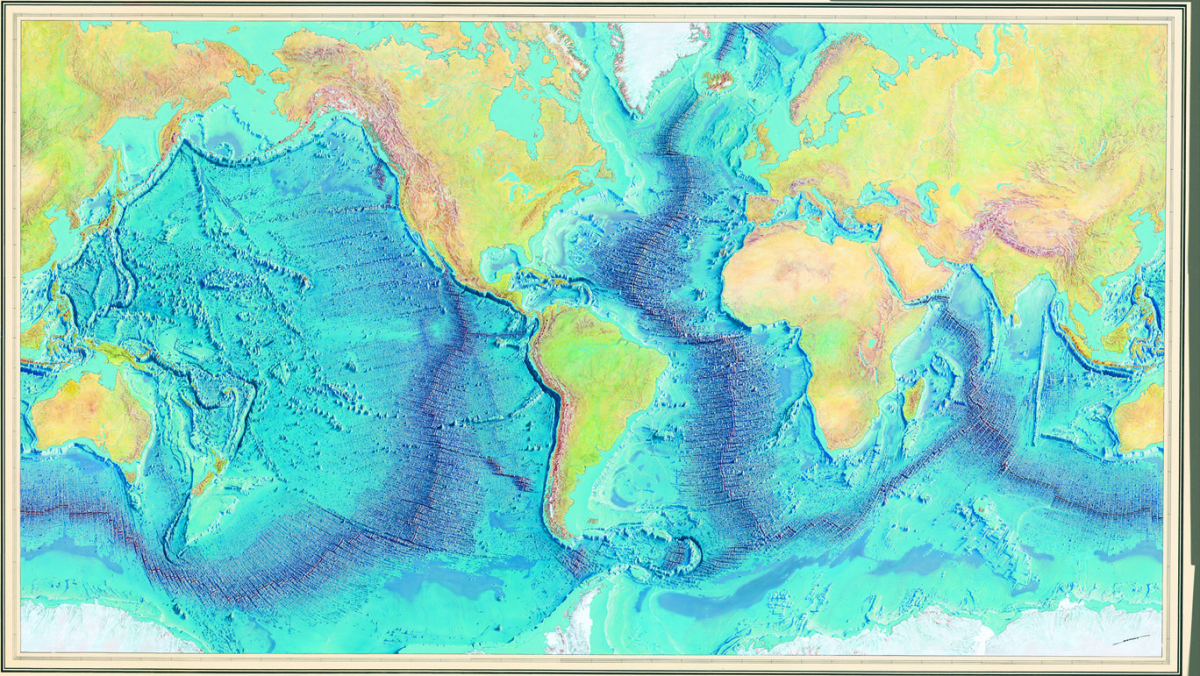
I was shocked when I realized how little difference there is in height between being above or below water level sometimes. Like the first image on this page: https://www.research.ibm.com/people/l/lloydt/color/color.HTM You can't even see the transition, it's so flat.
Because the slope of topography/bathymetry is so flat, relatively small changes in sea level (order of 10s-100s of meters) can dramatically change the connectivity of land (and oceans). This allows for both the migration and isolation of species on earth, notably the migration of humans to the Americas[0].
The major differences in elevation/bathymetry are dominantly due to the density change that accompanies the change from continental crust to oceanic crust. Continents are basically rafts of granite that float on more dense mantle rocks; oceanic crust is pretty close chemically and physically to the mantle, and is a lot thinner and more dense, and basically floats lower. This equilibrium is called isostasy[1], which is more or less Archimedes' principle[2] applied to the earth.
It's basically happenstance that the volume of water on earth is enough to just barely overtop the ocean basin. Very fortuitous happenstance, though (life might have evolved pretty differently if the ocean/land transition was several km high).
Though many of the ideas of plate tectonics were several decades old (including Emile Argand's beautiful and prescient ideas, including continental collision is the biggest driver of mountain range formation, and that subducted Indian crust underlies the Tibetan plateau [1]), until the 70s they were still widely disbelieved, even by straight up geniuses like the great Bayesian geophysicist Harold Jeffreys (he of the Jeffreys prior).
Tectonics is the grand unifying theory of geology, and wasn't really accepted until the 70s. How old was 'modern' physics at this point? Darwinian evolution?
What else do we still have to discover? I like to keep this in mind when I hear the doubters doubting (e.g., [2]).
[1] Argand, E. (1924), "La Tectonique de l'Asie", Extrait du Compte-rendu du XIIIe Congrès géologique international 1922 (Liège), 1(5), pp. 171-372.
[2]: http://www.telegraph.co.uk/science/6694932/Have-we-discovere...