I subscribed to the FAA alerts a couple of years ago after learning that the GPS interference tests were one of various causes of so-called “flyaways” (unexpectedly losing control of a GPS guided drone).
Anyway, since then I’ve gotten an alert about these tests almost every month or so for the last couple of years.
Not sure why a big deal is being made about this particular one...
As I understand it the military wants to prevent the FAA from decommissioning radio NavAids and secondary radar. The FAA had counted on $100 billion from the decommissioning after the introduction of ADS-B. Jamming GPS signals forces aircraft to rely on the old systems, so it has become part of a politics game.
Interesting. I was under the impression that GPS was made available to Civilians by Reagan after the Soviets shot down a South Korean plane that strayed into Soviet airspace. Their tools and training were ineffective at guidance and they got shot down.
Reagan made GPS open to international civilian use because there was literally no other tool that could accurately help planes not get murdered by the Russians, etc.
But now you're suggesting that the older tools were effective enough and should remain in place 30 years after civilian GPS?
Redundant systems are almost always good in aviation. The ICAO report[0] indicated either a system failure or user error resulted in the A/P’s INS mode failing to activate and instead remaining in HDG mode.
Yes, the old systems are effective. A lowly candidate private pilot must demonstrate proficient VOR navigation to obtain a certificate — not sure about light sport, recreational, or gliders — along with commercial pilots and airline transport pilots (ATPs). GPS is not mandatory equipment. Even if so equipped, the GPS can fail.
Yes, at least some of the redundant ground-based radio navaids should remain in place as backups.
My father got an 18 metre 1970s-vintage yacht in 1994 or thereabouts. I remember learning to plot accurate fixes using LORAN signals and hyperbolic TD lines. Getting good at that and coming up with (what I thought) were really clever transformations between Euclidean maps with hyperbolic curves to straight lines on a curved surface served me very well (at least in terms of intuition) when later I learnt of non-Euclidean geometries.
(I also remember looking through ancient manuals and building up an intuition for troubleshooting and fixing a thermionic valve-based RADAR, at least once in high seas with almost zero visibility as howling winds and lashing rain was pushing us towards a rock face. Fun times.)
But there's now glonass (russian gps) and galileo (eu gps) and I just learned that India and Japan have systems. I want my receivers to use as many of those as possible. they can go out and be spoofed and when the next big one comes, who knows what will be working.
On top of that: isn't the solution for USAF to stop jamming a widely civilian used protocol?
Forcing others to keep using old tools and not realy on newer and better tools just so they can jam it at will seems counterintuitive
It's not a civilian protocol - it's run by Air Force Space Command (the 2nd Space Operations Squadron) primarily for the benefit of the military, but as a matter of policy, the DoD also makes it available for civilian use. The key point is that military use comes first.
As a private pilot, this is the kind of thing that makes me scared to fly without being well versed on radio nav aids. I feel like i know them well, but honestly i use them so rarely in practice it would likely be an uncomfortable situation.
Most GPSs these days support GLONASS as well, my previous generation pixel phone does. Not that one shouldn't have a backup plan in case of a disruption of both.
My understanding is that it might be the gps system sending fake data, not being shut down or completely scrambled. So you might not know you are wrong.
Normally by "jamming" they mean broadcasting noise that downs out the GPS signal. It's a lot more technically difficult to "spoof" the signal and would require transmitters throughout the region, or control of the satellites themselves. Of course the US military has both of those things, but I'd still expect jamming rather than spoofing.
There's no chance the U.S. military doesn't have the ability to selectively knock GPS out nation-wide. Odds are the American government has infrastructure in place to do the same in dozens of countries worldwide. GPS would never have been made available to the consumer market without this level of absolute control having been put into place.
It's frightening to see how casually the American government takes disrupting GPS. The fact is, there is risk in performing these tests near civilian populations. It takes one pilot - or someone else who depends heavily on GPS - to make a fatal mistake. It's not physically necessary to black out GPS for training... just take away the trainees' hardware, or program the firmware/software to act in the desired way. "How do we train our troops not to rely on GPS? I guess the only way is to disrupt GPS for a thousand miles around the training site!"
I think these tests should happen military excersizes or not. In fact turn the entire constellation off for 24 hours at random periods once every few years or so.
The over reliance on the GPS system is downright scary, and I doubt we even have a real idea of where the second-order effects lie. What happens when all the CDMA towers lose clock sync? Are airmen still able to actually navigate? Etc. etc.
Civilian preparedness needs to be part of national security "training" as well - and GPS is one of the largest vulnerabilities we have as a nation no one talks about.
One second-order effect would be large number of people that would be unable to leave their house and make it to the local grocery without the use of GPS. It never ceases to amaze me how many people that I will ride with to go somewhere local, yet they will insist on using the nav system.
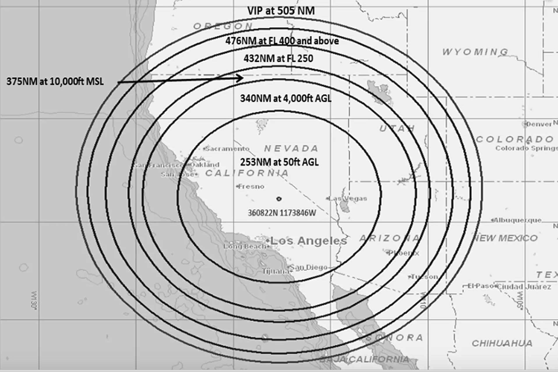
"The NBAA Command Center reports the U.S. military will begin training exercises on the Nevada Test and Training Range between 0400Z until 0700Z daily. Training maneuvers will impact vast portions of the Western U.S. including California, Nevada, Oregon, Wyoming, Arizona, Utah, Colorado, Montana and New Mexico. FAA enroute ATC centers affected include Albuquerque (ZAB), Denver (ZDV), Los Angeles (ZLA), Salt Lake (ZLC), Oakland (ZOA) and Seattle (ZSE). Operations in R-2508 and R-2501 may also be impacted.
Arrivals and departures from airports within the Las Vegas area may be issued non-Rnav re-routes with the possibility of increased traffic disruption near LAS requiring airborne re-routes to the south and east of the affected area. Aircraft operating in Los Angeles (ZLA) center airspace may experience navigational disruption, including suspension of Descend-via and Climb-via procedures. Non-Rnav SIDs and STARs may be issued within ZLA airspace in the event of increased navigational disruption. Crews should expect the possibility of airborne mile-in-trail and departure mile-in-trail traffic management initiatives."
Yah, not clear. I was going to be annoyed since I plan to go hiking this weekend in California. Probably would have been good to practice the old map and compass stuff, actually.
Most maps for hiking/backcountry use are topographic. If you generally know what line you’re on, like a trail or along a creek, you can match your altitude to the elevation on the map and identify your position. It’s a lot quicker and easier than finding a point, taking the angle from a compass, and plotting your position on the map.
And a time-saver over the old technique used in case of getting lost where you just went downhill until you reached a road (this got some friends & myself un-lost in the Sierras back in the 80's)
Careful, there was just a rescue the other day in socal on my. Baldy where a woman got stuck trying to do basically this. It was too steep to go back up and there was a waterfall below. Had to be rescued. Still not the worst idea.
Why?
GPS jamming doesn't break maps on the phone, or the compass on the phone.
So no need for paper maps or old-school compass.
You just don't get the "where-am-I" functionality of the maps, but you can move the screen yourself, just like in the old maps.
Note: the USA demanded that Galileo signals be broadcast on frequencies that it could block/jam without simultaneously running its own GPS signals, so as to interdict potential enemies without degrading its own forces’ ability to use GPS (which one assumes would be switched to encrypted-only mode in the event).
I wonder, will the GPS jamming cause any disruption to (or, worse, deviation of) GPS time signals? If yes, that could cause some interesting effects to NTP servers and appliances that use GPS as their stratum-zero source of time.
When a GPS disciplined time server or server appliance encounters a condition where the GPS signal becomes unavailable or unreliable a local oscillator is used to keep time. The local oscillator is generally a TCXO, OCXO, or Rubidium standard. Such systems are able to deliver fairly accurate and precise time in the event of a short outage like this. A quality server with a local Rubidium oscillator should be able to keep accurate time within 10 μsec in the event of a five day outage.
GPS signals can become unavailable for numbers reasons that are far more mundane than being jammed such as someone disconnecting the antenna, lightning strike, a rat chewing through the cable, meth heads stealing the copper cable and/or antenna, etc.
A few months ago one of the satellites was still broadcasting while it was down for routine maintenance, reporting some time that was off by a third of the distance to the sun.
There are enough weird GPS errors that I'd hope they have a backup plan already.
They did, so actual GPS location chips weren't thrown off. But apparently there are GPS-based clocks out there that don't actually bother to read the almanac.
(I'm a few layers removed from the error report where I saw this so I don't really know the details.)
How many NTP servers run off GPS? My understanding was that most people just piggy backed off pool.ntp.org and didn't bother running their own stratum 1.
  Grandmaster Clock [...] equipment designed for deployment
  in the mobile backhaul network, at macro base station
  sites, or small cell aggregation locations. [...]
  meet the stringent timing and synchronization
  requirements of 4G/LTE networks
In other words: Applications that need sub-millisecond-level precision, such as mobile phone base stations, where multiple towers coordinate their transmit/receive windows to avoid interfering with one another.
I'm currently building one for fun using a Raspberry Pi and a cheap GPS module from Aliexpress. I don't think a lot of hobbyists do it, but it's pretty common for stuff like datacenters to have their own local GPS disciplined NTP server.
It's not that hard to make one yourself by the way, and the hardware costs about $15. At the pro level you can get rack mount units with GPS + an on board TXCO/OXCO/rubidium frequency reference. You can probably get one with a cesium reference too, but I don't think that's much use outside a metrology lab (and will cost a fortune).
Using a raspberry pi as a GPS NTP timeserver greatly amuses me since the raspberry pi doesn't ship with an RTC (or at least last time I checked). As a follow up question, how does the system time get set on one of these time servers? Does the NTP process have rights to update local system time or does the system rely on requesting NTP from itself?
System time gets set either from the GPS signal if not connected to the network or another NTP server if you are at boot. The satellite gives you a coarse time directly (accurate to milliseconds I think), plus a high precision frequency reference driven by the onboard atomic clock, which NTP uses to keep time. Once setup, this thing is supposedly capable of stability in the microsecond range, which is better than you'd get relying on an external server (dunno if true yet however).
NTP can set your system time I believe.
Lack of a RTC doesn't matter in this case because you wouldn't want one, they typically aren't stable enough. You're not supposed to turn it off very often anyway. If you were more serious about it than me you'd probably add a rubidium oscillator to serve as a secondary reference when GPS is offline and hook the whole thing up to a large battery, so that it never turns off. I don't care that much though, I'm just having fun with cheap toys.
Also cool. I opted for GPS because I had a spare Pi and you can get dubious but perfectly adequate GPS modules for $3 off of Aliexpress, it's kind of an impulse buy. I also picked up a MAX7219-based LED display for another $2, so it's also going to be an over-engineered desk clock for $15 + some 3D printed parts (the other $10 is for a Pi Zero W I had left over from a different project).
They’ll be sending fake signals, i.e time shifted. Since the speed of light is enormous, we’re probably talking micro- to millisecond disturbances. No worries for regular NTP servers I’d imagine.
if what they are doing is jamming, then if you are getting timing information from a gps receiver and your receiver is in range of the jammer you will get the timing information from the jamming signal, so yes, however the USAF _might_ be including the correct timing information in their jamming signal in order to reduce any side effects of their exercise...
The IMAX movie Fighter Pilot: Operation Red Flag was pretty cool if people want to see more about this training exercise. The level of coordination to pull this whole thing off is staggering.
I wonder what sorts of things they need to account for in this day and age of drones, digital warfare, etc.
Given that an individual or state could implement such an attack, I would imagine it wise to test the impacts of an GPS jam on the otherwise normal running of society. How many delivery drivers don't know how to get anywhere within a GPS?
If the goal is to similate navy pilots flying with intermittent GPS, they should add a test mode to their planes receivers rather than jamming which disrupts all planes.
When I was in the Navy, I participated in similar exercises. Operating in a GPS-denied environment is only one objective we trained on. Identifying that you were being jammed was also key. GPS jamming looks just like the "Huh, we're not locking on any satellites yet, better restart it" that we've all experienced with our car or smartphone.
Also, it's likely that there are classified counter-counter-GPS systems or tactics that are being tested or trained on during Red Flag and other similar exercises, but these won't make it into the press.
Testing the jamming is as much a part of the exercise as anything.
That, and jamming is not a binary thing. Real-world exercises on something like this yield far better training than simulations, which is what a test mode would be.
They probably don't want to have a facility in their software or hardware that could accidentally (or purposely) be set to disable GPS during normal operation. Even something physical like a switch would make subtle sabotage easier.
Eh, such features aren't new or unusual. For example most aircraft have a "master arm" switch that enables firing weapons. Typically they have three settings: off, arm, and simulate (or something comparable).
I guess it's the same as IT switching off a data centre to test its resiliency. It's a bit blunt but that's the only way all sort of unsuspected dependencies surface.
If you want to see some crazy US Air Force training, youtube "red flag training". Those videos give an amazing perspective on what our military is trained to do.
The air force is easily a 3-trillion dollar organisation - that's what it would cost to rebuild machinery, equipment and know-how over decades if it wouldn't exist.
Yes, it is definitely against credibility that an otherwise mostly civilized country would spend more than half their tax income on efforts to torture and kill millions of people.
Very not my field, but for context which hasn't been mentioned here yet: GPS spoofing attacks appear to have become more accessible of late, and to have occurred in the wild (notably on the coast of the Black Sea). And jamming could be relatively easier.
GPS jammer is an important equipment for GPS positioning, which is very important for anti-tracking and protection. It's good for your safety.
https://www.jammer-buy.com/gps-jammer/c-25.html
The imaginary enemy may be China and Russia. Russia, in particular, has a very powerful disruptive force.
China and Russia will work closely together to try to prevent the outbreak of conflict. Hopefully there won't be a major outbreak of war.
source:
http://www.perfectjammer.com/gps-blockers-jammers.html
If you're curious what the Russians will be deploying in remote areas (outside of aircraft) this is their primary electronic warfare vehicle which can jam low-orbit satellites, which I'd imagine includes GPS and other NATO networked systems.
> The Krasukha-4 has the range for effectively disrupting low Earth orbit (LEO) satellites and can cause permanent damage to targeted radio-electronic devices. Ground based radars are also a viable target for the Krasukha-4.
It kind of baffles me that today the best solution we have to the problem of navigation is still based on the concept of having satellites in the space. Is there an ELI5 answer to why we can't have a decent system of figuring out where we are on this planet without making any unstable additions to it?
Well why do you think we should? I don't know of any positioning principles that do not rely on measuring the distance to some known reference -- be it a star, sattelite, ground station or your place of departure.
I'm not sure there IS an alternative. Ultimately, knowing where you are is in comparison to some known location (even inertial navigation is based on knowing a starting location and tracking movement away from that). GPS "just" provides a set of globally-visible waypoints rather than having to map those that are only locally-visible ahead of time.
In theory, I suppose you could use the movement of astronomical bodies to do the same, but making a portable device that can automatically detect (without necessarily LoS the sky) the relative positions of sufficient markers seems like a tough ask.
Because there is no cheaper solution that's reliable.
I think when we figure out affordable global positioning without needing external infrastructure, we'll unlock a major technological milestone as a species. Right now you can do this for short periods of time with multi million dollar INS solutions which are used exclusively by the military.
My guess is the answer will be in SLAM augmented with some other sources of data. See googles project tango.
Anyway, if you want a global system with sub-meter accuracy, you will have to continuously adjust it. If you settle for ~100m accuracy, you can create something that will last for a long while without any intervention by using satellites.
Hasn't there been stories here about the GPS signal near important buildings in Moscow being shifted 20 blocks or something? Regardless, after a second I'm totally up with it being messed up sometimes. If it never turns off you literally don't know how to live without it.
This makes so much sense... Yesterday I saw at least 6 Apache helicopters take off from the rather small Champaign, IL airport. Earlier this week I saw some strange jets as well.
Was pretty confused, but they were probably moving around for this exercise (either too or from).
I thought they also relied on highly precise maps hence gps would matter. Though gps is unreliable if you need to be on the right lane of the road so I assume they have fallback mechanisms.
I think they definitely require GPS or some form of satellite navigation mechanism to work. I really don't think they can use the local built-in radar to position themselves. I believe until now they have taken it for granted that GPS will always work. Theoretically we can place ourselves in the map based on visual recognition and radar, but its much more difficult than using GPS, and I don't think any of the current implementation have thought of a fallback mechanism..
Given a map, and starting from a known position, it is perfectly possible to know where you are by continuously updating your position by knowing your direction and distance covered, corrected by recognizing features on the map as you reach them. When done from boats or airplanes, this is known as pilotage, but it is much easier on land, where there are no winds or currents, and even easier when restricted to a road network. I don't know whether any autonomous car is equipped to do this, but it would seem to be one of the lesser technical problems of the field.
I believe it will be difficult in land than it is in air or water. For e.g., how dependable would be the the recognizable features, especially in lesser known roads. Without that if the vehicle narrowly misses a road (could be due to a new road coming up or slight mismatch in the map or a temporary diversion) then the direction and distance would quickly become useless as it can't place itself anymore in the maps. Human beings can use their intuition or ask someone to correct themselves, but it would be very sophisticated to implement on a self driving machine.
It is not correct to say that your displacement quickly becomes useless once you encounter some discrepancy in your map. It remains valid as a good estimate of your position, allowing one to recover from map errors so long as they are not pervasive. This is not a trivial programming exercise, but nor is it as difficult as many other aspects of vehicle automation.
If they did, they would be crashing into parked cars and buildings as well. GPS can not be the basis of fine navigation, and it does nothing for collision avoidance.
they wouldn't be able to turn it off over a single geographic area as the GPS satellites are broadcasting from space but they might be able to turn Selective Availability (SA) on for individual satellites however that would downgrade the signal received by every GPS receiver in view of the satellite until they turned SA back off
Modern GPS satellites don't know how to do Selective Availability, this feature was not being used, so implementing it in spacecraft (which is not free) made no sense and new birds aren't fitted with it.
Newer models of GPS satellite implement a new variant of COSPAS-SARSAT instead, unlike a Geostationary satellite they pass over the whole Earth's surface, so they can see your rescue beacon from anywhere, and unlike the weather satellites used in the past to cover the whole surface they have powerful transmitters in the right frequency range already, so they could reply.
Today (in testing only) this means faster rescue after triggering a beacon. Search and Rescue resources will know where you are (often to within metres) just minutes or even seconds after you activate the beacon, an improvement on prior models (10+ minutes on most of the surface, up to hours nearer the poles) and eventually new beacons will be able to tell you that rescue is coming perhaps with short text or coded messages e.g. "Mountain patrol on their way. ETA 48 minutes. Stay where you are if safe."
Cryptography (P-code or M-code) protects against spoofing not against straight forward jamming. 10-watt jammer can deny large area from military ans civilian signals.
You need more advanced antennas and other methods to protect against jamming. These multi-element controlled-reception pattern antennas are larger and more expensive.
Jamming is denial of service. If the transmission medium is flooded with a high noise floor, digital signal processors will fail to decode any valid values from the band the carrier signal transmits on. Authentic signatures have no utility if excessive noise outshines the entirety of the signal.
No one can check any signatures, if the signed message cannot reach an audience.
Perhaps an aperture could prevent omni-directional cross-talk and interference, forcing a receiver to only listen from a specific, selected line-of-sight source, but to simulate warfare, what if the enemy really does manage to completely destroy a resource?
A genuine disruption keeps everyone honest in the spirit of the exercise. It’s really down. Not just “what if”? No peeking. No cheating.
For this, the attack is from the operator of the GPS signals. There is no defense; the attacker could digitally sign the signals or even shut off the satellite.
For an attack in a foreign country, digital signatures only prevent false information. A digital signature does you no good if the interfering signal is far stronger than the desired signal. The desired signal may even go missing if the enemy attacks the satellite.
Military users can choose to use encrypted GPS signals. This at least lets them know to ignore an attacker, but doesn't help with hearing the legit signal. Military users sometimes use highly directional antennas to avoid picking up jammers near the ground, but that is no help against an enemy that can put a jammer in their own satellite.
Encryption probably doesn’t solve the replay attack problem here. If you can jam + retransmit the signals from the satellite with a sufficiently small delay, then you can change the position the receiver computes.
"Attack" implies something that I don't think is going on here. They developed the system and have full control over it. This is like saying if Google were to stop serving a certain locale for a certain period of time that they were attacking their own service.
I'm in the Bay Area, should I be concerned that my GPS will be disrupted? "Western U.S." is a big area. Maybe I should click on it just to be sure? Heeeey, yeah, clickbait. Maybe an innocent mistake from a headline writer who lives in the Eastern US? Neah. Clickbait.
They could also say they’re jamming GPS in a radio room in an Air Force base, but it wouldn’t change the fact that the jamming will impact a multiple state area, including Colorado and the coast of California.
I subscribed to the FAA alerts a couple of years ago after learning that the GPS interference tests were one of various causes of so-called “flyaways” (unexpectedly losing control of a GPS guided drone).
Anyway, since then I’ve gotten an alert about these tests almost every month or so for the last couple of years.
Not sure why a big deal is being made about this particular one...